
Beautiful Hungarian Map 2014 – exhibition

This year a total amount of 41 maps entered the ”Beautiful Hungarian Map 2014” competition. An exhibition of the competing items will be open until April 11, 2015 in the Ceremonial Hall of National Széchényi Library, on Floor 6 of the Library.
With the exception of one digital work, cartographic works entering the competition were all published in print form. Both targeted users and the areas presented by competing maps are rather diverse. All in all, it can be said that the majority of items sent in shows a commitment to making high-quality maps.
According to the jury’s decision, the following maps came out as winners:
Category of “Beautiful maps”
1st prize was granted to Zemplén Mountains [contestant: Nyír-Karta Limited Partnership]. The most beautiful Hungarian map of 2014 depicts the Zemplén Mountains and it was made for tourists and cyclists. Both the esthetic form and the content of the map were highly appreciated by the jury who granted 1st prize of the category unanimously.
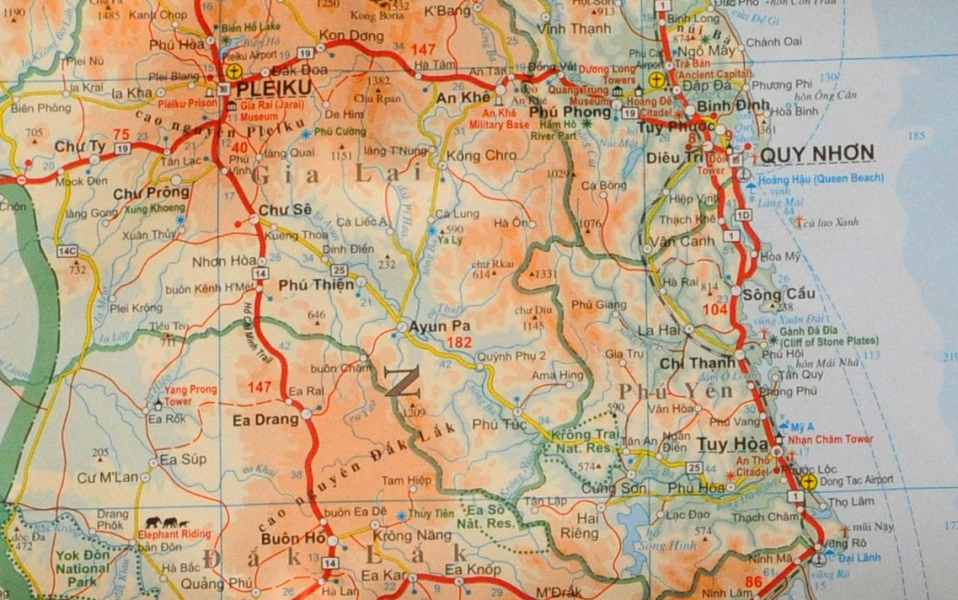 2nd prize was granted to Vietnam – Laos – Cambodia [contestant: GiziMap].
The 1:1 400 000 scale general geographical map is aimed at tourists and businessmen interested in the countries of the Indochina Peninsula. The colors and content of the map, rich in geographical names, gives a real esthetic experience. Legends of the map can be read in six languages. Names of states are given in the original language (e.g. khmer, alo, thai) as well.
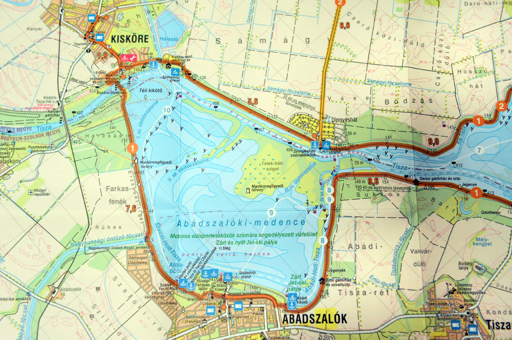 3rd prize was granted to Active map of Lake Tisza [contestant: Cartographia].
The 1:50 000 scale map is meant to serve users who like to spend their free time actively, in the heart of nature. The map gives a detailed description of bicycle tours, water tours and fishing places related to Lake Tisza. It can be used actively in the literal sense of the word; it is made of waterproof material, making it possible for users to write on the map with a felt pen.
Category of “Scientific Maps”
In this category, no 1st prize was granted by the jury.
 2nd prize was granted to Stream map-album of the River Danube, Danube at Ráckeve (Soroksár) [contestant: HM Zrínyi Térképészeti és Kommunikációs Szolgáltató Közhasznú Nkft., Ministry of Defense, Zrínyi Cartographic and Communications Services Charitable NLtd.]. It is a scientific atlas in three languages (Hungarian, English and German) which serves as a valuable source for research on the River Danube.
 3rd prize was granted to: Szeged (Hungarian Atlas of Urban History 3.) [contestant: Csongrád County Association of Local History]. The atlas, published in Hungarian and English, is a niche topographic publication, a comprehensive work which can be used as an essential source of research into urban history.
Honorable mention was granted to the following maps:
Tourist routes in Hargita Mountains [contestant: Csongor Kovács];
T-series (tourist maps for iOS phones) [contestants: András Szarvas and Árpád Bedő];
From the river Drava to Danube [contestant: Cartographia].
Date: The exhibition is open between March 27 and April 11, 2015 (Tue-Sat: between 10 a.m. and 6 p.m.)
Venue: National Széchényi Library, Floor 6, Ceremonial Hall
Photos taken of granting the awards

KÖZÉRDEKŰ ADATOK | ADATVÉDELMI ÉS JOGI NYILATKOZAT | © OSZK 2015–2024

| GYORSMENÜ |

|