
Tabula Hungariae. Lázár’s map and its versions
Tabula Hungariae. Lázár’s map and its versions, Ingolstadt, 1528.
Electronic document
Budapest, OSZK MEK, 2007. DVD-ROM
ISSN 1788-1188
ISBN 978-963-200-532-4
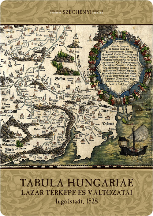
The first map of Hungary with only one existing copy known was published in mid-May of 1528 in Ingolstadt, by the printing press of Petrus Apianus. The work of Lázár, a 16th century Hungarian scholar of mysterious fate, was taken to Vienna by Johannes Cuspinianus, rector of the Vienna University and diplomat, who had it printed in a version re-edited by the professor of the Vienna University, Georg Tannstetter. The map reappeared in 1880 after a long time of unknown whereabouts. It was purchased by Count Sándor Aponyi who donated it to National Széchényi Library in 1925.
The Tabula Hungariae was included in the Memory of the World Register of the UNESCO on the 19th of June 2007, together with 38 other artworks.
Digital Treasury is the e-publication series of National Széchényi Library that contains the full digital copies of the most valuable items of its own and occasionally of other collections of old books, manuscripts, periodicals, maps, small prints, posters, audio materials etc. The series is edited by the Hungarian Electronic Library Department with the cooperation of experts at NSZL. We publish the copies in two versions: medium quality for quick use and premium quality for detailed research.
Shopping
Our publications are available in our bookshop, or can be ordered from the Publications Department of the NSZL using the contact details below: Főigazgatói Kabinet kiadványtára, Országos Széchényi Könyvtár, 1276 Budapest P.O. box 1205., phone: 06 1 232-3556, e-mail: kiadvanytar@oszk.hu.
DATA OF PUBLIC INTEREST | PRIVACY POLICY | © NSZL 2015–2024

| MENU |

|